Clicking a point on the map causes a Cell Data pop-up to appear (Figure 13).
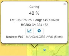
Figure 13. Primary cell data pop-up
This pop-up includes the:
- numerical indicator value for the cell for which the selected point falls within
- Latitude and Longitude and MGRS grid reference for that point
- Graph button (for opening meteograms)
- Expand button (for obtaining more detailed cell values) and
- name and proximity of the Nearest Weather Station to that point (if there is one within 10km)