Additional spatial layers
In addition to the layers described in Table 2, Foresight Planned Burning displays the following data layers (Table 6).
Table 6. List of spatial data layers only available in Foresight Planned Burning
| Indicator Group | Indicator | Description | Source | Source System/Product | Data point duration (temporal resolution) | Cell size (spatial resolution) | Accessibility |
| Incidents | Burns – Ready | This is a planned burn that is ready to be ignited. | DELWP | eMap / FMS | n/a | n/a | All users |
| Incidents | Burns – Scheduled | This is a planned burn that is scheduled for ignition. | DELWP | eMap / FMS | n/a | n/a | All users |
| Incidents | Burns – Ignition Authorised | This is a planned burn that is authorised and awaiting scheduling. | DELWP | eMap / FMS | n/a | n/a | All users |
| Incidents | Burns – Ignition | This is a planned burn that is being ignited. | DELWP | eMap / FMS | n/a | n/a | All users |
| Incidents | Burns – Under Control 1 and Burns Under Control 2 | This is a planned burn where ignition is complete but may have hot spots and is being patrolled | DELWP | eMap / FMS | n/a | n/a | All users |
| Incidents | Prescription Evaluation | Overall evaluation based on prescription recorded in the Fuel Management System. Green outer circle shows planned burns that meet the prescription for that hour. Yellow outer circle shows planned burns with only one variable out of prescription, or only a few out by less than 10% for that hour. Red outer circles show planned burns outside of prescription. Grey outer circles shows planned burns where no prescription has been recorded in FMS. |
DELWP | FMS and Foresight | Hourly | n/a (applies to burn point) | All users |
| Incidents | Fuel Treatment Areas | Total burn polygon area | DELWP | eMap / FMS | n/a | n/a | All users |
Data tables
In addition to the weather variables, the Foresight Planned Burning data table also shows the Leaflet 80 fire behaviour model and the Prescriptions data table (Figure 14).
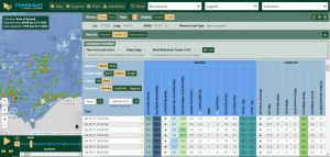
Figure 14. Data tables available in Foresight Planned Burning, showing the Leaflet 80 model data (Zoom for improved resolution)
When a burn is selected, a user can choose to open the Prescriptions Data Table to the right of the weather table for the burn location. This Prescription table should automatically use the prescription information stored in FMS for the burn. For points of interest outside of a burn, users may be prompted to select a Prescription Burn Class appropriate for the location (Figure 15).
![]()
Figure 15. Drop-down box requesting a Prescription Burn Class to be supplied for prescription calculations in Foresight Planned Burning (Zoom for improved resolution)
The Prescription data table shows key weather variables relevant to the prescribed conditions. It also shows a colour-coded and ticks/crosses display, indicating which variables are below prescription, within prescription or above prescription (this colour function can be turned off with the “background” option) (Figure 16). For even further detail, you can hover your cursor above the data cells in the Prescription table to see exactly what the weather values are and the relevant prescription ranges.
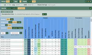
Figure 16. Data tables available in Foresight Planned Burning, showing the Presciptions calculation data (Zoom for improved resolution)