Additional spatial layers
In addition to the layers described in Table 2, Foresight Bushfire displays the following data layers (Table 5).
Table 5. List of spatial data layers only available in Foresight Bushfire
| Indicator Group | Indicator | Description | Source | Source System/Product | Data point duration (temporal resolution) | Cell size (spatial resolution) | Accessibility |
| Preliminary Forecast | Preliminary Fire Behaviour Index | Preliminary FBI values are early an indication to agencies of the potential fire weather ahead of time. | AFDRS | Gridded Weather^ | Hourly | 1.5 km | All users |
| Preliminary Forecast | Preliminary Max Daily FBI | This preliminary maximum FBI value provides an early indication up until 15 UTC. | AFDRS | Gridded Weather^ | Daily | 1.5 km | All users |
| Preliminary Forecast | Preliminary Max Daily FDR | This preliminary maximum FDR provides an early indication. | AFDRS | AFDRS text product | Daily | 1.5 km | All users |
| Incidents | DELWP/CFA Burns | All burns from status ‘Ready’ to ‘Under Control – 2’ | DELWP | eMap / FMS | n/a | n/a | All users |
Data tables
In addition to the weather variables, the data tables in Foresight Bushfire also display a range of fire behaviour models (Figure 13). The fire behaviour models available are:
- McArthur Mk5
- Leaflet 80
- VESTA
- Grass
- Mallee Heath
You can use the tab at the top of the data table to select a fire behaviour model. This will display the relevant model output for that location, using the forecast weather and fuel variables for that location. The calculation variables, fine fuel load, slope and wind reduction factor for the model selected is displayed at the top of the table and can be edited by all users.
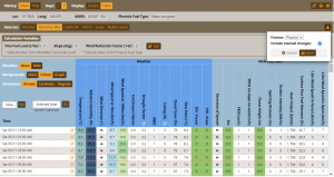
Figure 13. Data tables available in Foresight Bushfire, showing the McArthur Mk5 model data and the export function selected (Zoom for improved resolution)